
Today Jen, Nigel and I hiked up to the top of Mount Moosilauke. We took the Gorge Brook Trail up to the top and the Moosilauke Carriage, Snapper, and Gorge Brook back for a loop hike. It was beautifully windy (and a little chill) at the top. There were some bugs on the hike back down - mostly annoying, not biting much. The winds were bringing the Canadian fire haze, smoke and smell with them. It was hazier than it should have been.
Jen and Nigel near the top:
 |
| From The 48 by 48 Blackberry Pictures |
With the walk from the car, it looked like just over 8 miles with my GPS. The book mileage says 7.5 miles. It took us about 5.75 hours including all the stops. It was approximately 2600 feet gained and lost for the trip.
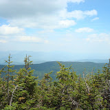
Franconia Ridge from the top of Moosilauke:
 |
| From The 48 by 48 Blackberry Pictures |
Click on picture to the right to see pics from this trip using Jen's camera:


No comments:
Post a Comment